The second edition of our 2020 West Norfolk Cycle Routes map is now ready to download and print. Thank you to those who gave comments and feedback on the first edition.
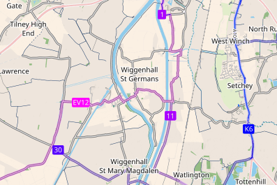
It is designed to print out in colour on A3 paper. One side has an overview of West Norfolk and the surrounding areas that emphasises cycle routes (purple and blue shading) and cycleways (dark blue lines) while using light colours for major motoring roads to avoid emphasising them. The other side has a larger-scale view of King's Lynn, showing cycleways (red lines) and cycle routes (red or blue dots) as well as road names
Just click below to download the PDF. Share it with friends. Print off more copies. Sell some. The mapping is Copyright 2020 OpenStreetMap Contributors and the graphics are produced by cycle.travel (who would welcome your Patreon support) and cyclOSM.org (who would welcome help).
If you don't have access to an A3 colour printer, doxDirect.com will print A3 colour double-sided unbound. If you fold the printed map into three like a letter, first in one direction and then the other, you can unfold/refold it concertina-style, like a simplified Miura fold.
If you would like more maps or online maps, please visit our list of local maps.
Feedback on the map is welcome, of course.