Please send any objections as soon as possible to 20/00724/FM which you should be able to do by clicking "Respond to this consultation" on https://www.streetfocus.uk/map/KingsLynn/20/00724/FM/#15/52.74718/0.42518 - after 29 March 2021, email borough.planning@west-norfolk.gov.uk with 20/00724/FM in the subject line and hopefully your comments should be received as late correspondence for the planning committee.
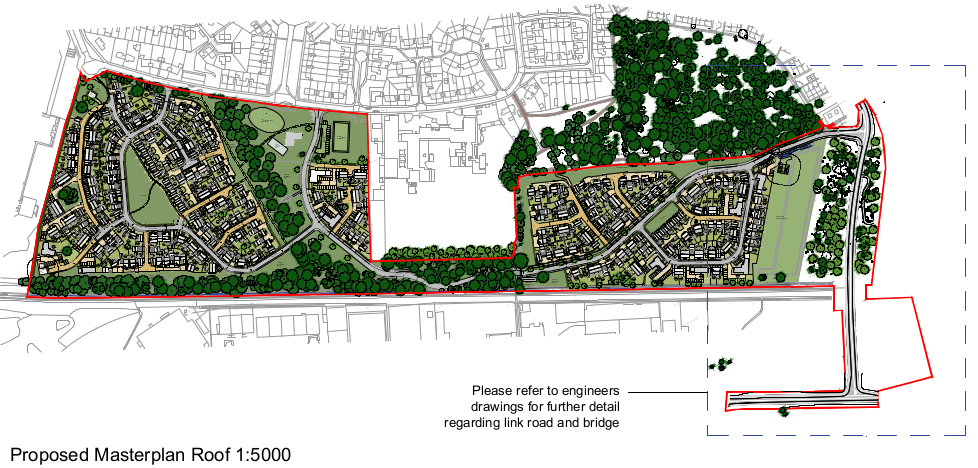
This development would be of 380 houses in two areas: one group is the park between Gaywood Parkway and the Sand Line Path (officially "Swaffham Belt Cycleway") and the other would be on the scrub area between the Sand Line and the cycleway from the Iron Bridge to Fairstead and King's Reach. The two parts would be linked by a road between Parkway and Fairstead that squeezes between the Sand Line and the back of the Howard Primary School, crossing the existing cycleway. A new straight road would run from Fairstead south over the Sand Line on a large bridge to the east end of Rollesby Road in the Hardwick Industrial Estate.
Key Objection 1: Unsafe Highway Design
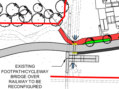
Where the new "spine road" between the two housing areas crosses the Swaffham Belt Cycleway, the designs are abysmal and seem to follow no recognised design manuals. The main crossing is this one at the west end of the primary school field:
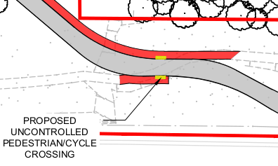
I assume the yellow bits are so-called blister paving slabs showing the width of the dropped kerb. No priority is given to people walking and cycling. The new bits of path look like minimum width for a cycleway, so anyone cycling between town and Fairstead would be having to make two tight turns across rough blisters to slalom across the road while looking both ahead and over their shoulder for motorists. About the only saving grace is that the spine road is proposed for 20mph.
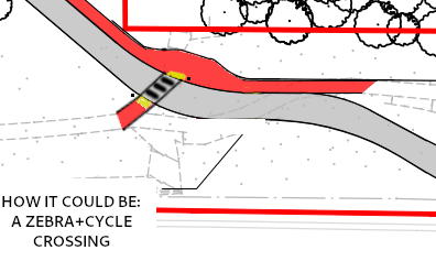
This is a massive downgrade from the current cycleway in several ways, including safety and convenience. As a minimum, there should be a zebra+cycle parallel crossing which has priority, positioned slightly further west with a realigned spine road so that it's easier for cyclists to cross the road at right angles and with enough space for people to turn their bikes onto and off of the cycleway without much risk of skidding along the kerb or running off the back of the cycleway. Something more like this:
This flawed junction design would have been completely obvious if the developers had bothered to submit "Swept Path Analysis" for the cycle design vehicle from the Design Manual for Roads and Bridges, rather than only doing swept path analysis for buses, bin lorries and fire engines.
Key Objection 2: Awkward Bridge Design
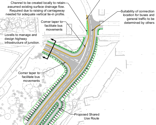
In their "Travel Plan", the developers claim that "the proposed development will enhance these links by providing a realigned ramp to reach the Iron Bridge access over the Sand Line railway line." Let's take a look at it:
This isn't being done to "enhance" the bridge! This is being done because the current ramp extends in a straight line to roughly level with the cut-off southeast corner of the school fence (shown in red) and its legs stand where they want to put the new road.
So instead of a straight ramp, cyclists heading down on the Gaywood side would have to make a right-angled turn right, then a U-turn left, then a U-turn right, then a right-angled turn left onto another no-priority road crossing, then if they are heading towards Gaywood Park or the western side of Fairstead, they'd have to make a tight turn left and a right-angled turn right onto the existing route. I'm not even convinced that the bridge ramp as drawn would let you ride down with a trailer, tandem or tagalong - but again, there's no "swept path analysis" shown. At best, people would have to wait for each other at each U-turn or elbow, turning the current two-way bridge into effectively a single-track.
Update (January 2021): we drew "swept paths" using the specifications of the Cycle Design Vehicle from the gov.uk handbook and no, it's not possible for a long bike (tandem or with trailer) to make the hairpin turns on that ramp, resulting in them crashing into the sides:

For a bonus, cyclists crossing from Gaywood towards the bridge would have their view of the road obstructed by a new tree, outlined in black on the green area to the right/east of the crossing. In the submitted junction visibility splays, the developers have not submitted anything for this junction.
It's difficult to know what to suggest instead. Ideally, don't connect the two areas with a carriageway (see below). But if they must, maybe they should add a flat section to the top of the bridge to go over the new road as well and move the current ramp further north, building over a bit more drain if needed to provide more width for the ramp to reach the ground - then the only people crossing the spine road east of the school will be those going to or from houses on that side of the road.
Key Objection 3: Creating New Rat Runs
At a time when many other towns and cities are introducing "low traffic neighbourhoods" and "circulation plans," it would be bizarre if King's Lynn squanders its historical advantage of being segmented by railways and waterways by building expensive bridges and culverts just to create new rat runs for motorists.
It's not difficult to forsee lots of people would use the Gaywood-Fairstead "spine road" and Fairstead-Hardwick "link road" to avoid the Eastern Bypass, QE roundabout and Gaywood Clock by driving through residential and industrial areas - and even more so when any of the frequent problems hit those areas. This may be intentional because the Gaywood Clock has a pollution monitoring station by it (the big green box), but southern Fairstead and northern Hardwick do not.
These roads look like cynical attempts to move cars away from the monitoring station without tackling the overall level of pollution in our town. Provision of a cycleway alongside a 20mph road is normally only done if motor traffic will be greater than 2500 vehicles Annual Average Daily Traffic and it has been done here.
The two housing areas and the adjacent employment area should probably be linked by only walking and cycling routes. There seems no good reason to build the road behind the primary school, especially.
Update (March 2021): it is now proposed to add a condition requiring restrictions such as bus gates to be deployed if the road gets too busy. We do not recall such a restriction being used or succeeding before, so we are not confident this will be sufficient.
Key Objection 4: Vague Highway Design
The Fairstead-Hardwick rat run is on different drawings to the Parkway-Fairstead one and is drawn up by Mott Macdonald rather than Lovells. It would cross the current cycleway to King's Reach and make new cycleway connections to King's Reach and the Hardwick Industrial Estate. However, it's difficult to say whether these are better or worse than the abominations described above because there's simply not enough detail shown.
There's notes about bus facilties but no details of cycling facilities: nothing about dropped kerbs or crossings or even which bits are cycleways and which are merely footways. For all we know, we could be left crashing down high kerbs again, like at South Lynn's NORA development or the more recent development in West Winch.
Not giving these key details seems like treating cycling and walking with contempt, despite various policies saying that active travel is the most important form of access and should be encouraged.
Update (January 2021): the design has been changed from the above, with the connection to Fairstead reduced to emergency use and three-point turns, and the cycleway staying on the east/north side of the link road, but some details are still vague and our experience is that vague details usually result in crap cycling provision.
Bonus Objection: Lack of Consultation
This planning application has been submitted after its pre-application consulation was announced as cancelled due to the coronavirus crisis in a news release. It then continued online without further announcement and the applicant has given media interviews claiming that response has been "largely positive" which seems misleading given the "cancellation". The consultation should be rerun with more publicity to allow everyone affected to see these plans and comment on them.
Comment Now!
Please send any objections before Wed 8 July to 20/00724/FM which you should be able to do by clicking "Respond to this consultation" on https://www.streetfocus.uk/map/KingsLynn/20/00724/FM/#15/52.74718/0.42518 or see above for late email comments.
Pingback: Response to Officer Report on Parkway Park Housing Plan | KLWNBUG - The Norfolk & Fens Cycling Campaign
Pingback: Gaywood Parkway Park: Decision Deferred | KLWNBUG - The Norfolk & Fens Cycling Campaign
Pingback: September Meeting and Consultations | KLWNBUG - The Norfolk & Fens Cycling Campaign