Both NCN1 and the Sand Line Path are expected to be closed this week for repairs (signs have gone up). Leaving aside the poor timing and coordination, here are suggested alternative routes:
Iron Bridge to Rail Station
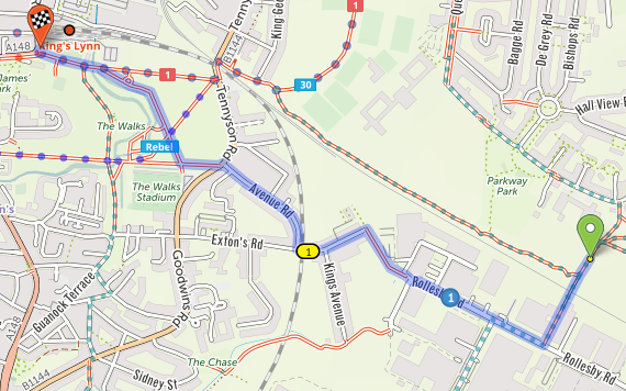
Cross the bridge to Rollesby Road. Turn right and continue to the end, then continue through two dodgy (illegal, disability-discriminating) slalom barriers onto Extons Place, then turn right after the level crossing into Avenue Road. At the end, cross straight over into the Walks and take the diagonal path past the cafe to the station.

If you can't pass the slaloms, follow Rollesby Road round the bend to the left, then take the cycleway on the right and take the first right into the end of King's Avenue. At the end, turn left onto Extons Place.
Rail Station to Lynnsport
Instead of going through the Walks to the level crossing and the closure, head north to Morrisons, take the exit from the far side of the car park into Highgate, use the crossing over the A148 into Kettlewell Lane, then keep right to use the little lane over the disused railway to the Long Pond, cross Loke Road to the other half of the Long Pond, then go around the right side of the park, fork right off opposite the takeaway, then turn right onto Salters Road. At the crossroads, go straight over into Greenpark Avenue and join the cycleway to Lynnsport.

Lynnsport to Edward Benefer Way
This is possibly the simplest: ride the roads parallel to the closed cycleway (Reid Way, Lynnsport Way, Hamburg Way). Try not to be put off by any silly drivers and consider reporting any that get too silly at www.norfolk.police.uk
Lynnsport to Iron Bridge
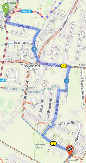
Exit through the bollards from the old (south) car park into Salters Road, follow the bend right into River Lane, then at its end, turn right onto the cycleway (paving) to the crossing. Cross and continue forwards along Gayton Road to the next crossing (beware the car parks and driveways), then double-back to Gaywood Hall Drive. Take the cycleway on the right part way down and turn left onto Bishops Road. Continue straight over Oak Circle and turn left onto Parkway. Turn right through the wide gate after the schools (the cycleway sign is currently missing) to reach the bridge.
Brave/confident riders may prefer to turn right past Aldi and then left into Queen Mary Road to reach Parkway at its far end, but I can't really recommend cycling through the awful Gaywood Clock junction to anyone.

Hope that helps! Please let us know on social media (hashtag #klwnbug) or facebook of any updates or problems.
