
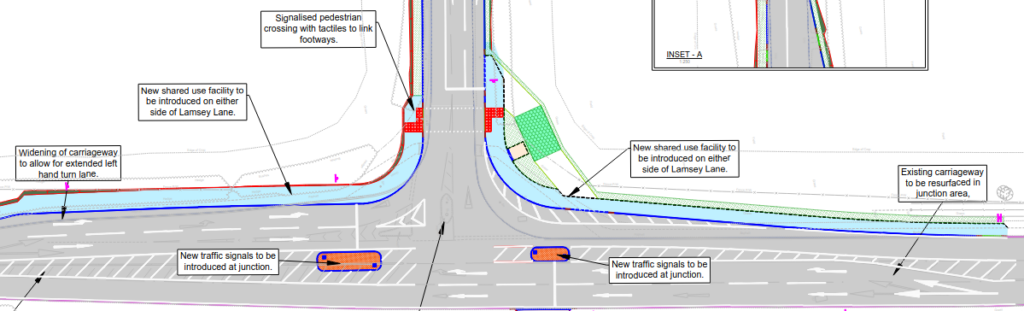
Norfolk County Council is asking for feedback on proposed changes to the Lamsey Lane junction with the A149 at Heacham and the consultation closes next Monday (26 May). I'll show you the current standard drawing in a moment, but here's what they're proposing:
and here's the standard drawing from the current UK Department for Transport Cycle Infrastructure Design manual (which says in the notes that it also applies to single-arm traffic light junctions):

And here's how a cycle lane should merge to the A149 northbound carriageway, instead of the shown dangerous "pantomime junction" (so-called because where's the dangerous vehicle coming from for cyclists? It's behind them!):
NCC really should be doing better than this old tat. So, I've submitted the following answers and suggest them to you too:
- (data protection) Yes (no other choice)
- (To what extent do you like or dislike...) Like them. (They're not great but we do still want them to go ahead, basically.)
- (Do you support signals?) Like them. (as with the previous question)
- (Please use this space if you have any comments)
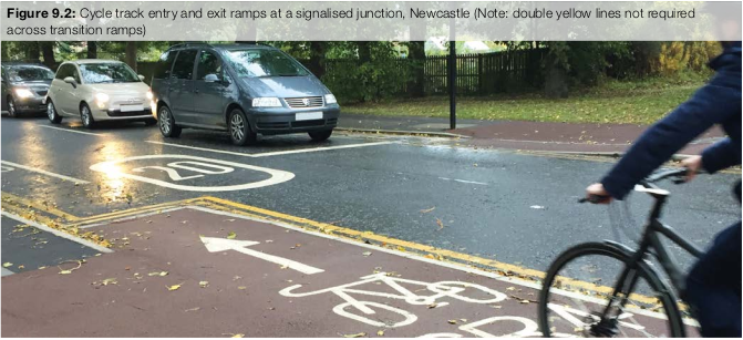
- KLWNBUG the Norfolk and Fens Cycling Campaign supports the basic principle but the proposed layout is outdated, substandard and unnecessarily hazardous to active travel. Layouts based on those shown in Figures 10.18 (main junction, with signal control as in the note) and 9.2 (for the merge and split for the carriageway) of DfT LTN 1/20 should be used instead.
- The positioning of a sign directly in the middle of the track of a Cycle Design Vehicle joining the cycleway from Lamsey Lane is unacceptable. Also, a merge from the cycleway into Lamsey Lane should be added.
- There is plenty of land safeguarded for this junction improvement, so there seems no excuse for making it such a dangerous low-visibility acrobatic obstacle course for active travel. This junction is on priority route HU/02 of the Norfolk Countywide LCWIP so please change it to a layout that enables active travel.
- (About you) Answer as needed.
You might wonder what the point of this little island of cycleway is when it doesn't connect to anything. Well, they've got to start somewhere! The pavement alongside the A149 to Snettisham Ken Hill roundabout has pretty much totally failed and we hope that when the council repair it, they also widen it out to enable two-way cycling, as part of the Norfolk Local Cycling and Walking Implementation Plan (LCWIP) route HU/02 (page 114). There looks to be plenty of space available in the A149 highway corridor: this is no narrow urban street or country lane. While the approved plans for the Ken Hill visitor centre include a cycle route away from the road that many may prefer in summer, it won't have a hard surface or lighting, so probably won't be as useful in winter as this would be. It might one day offer a more direct village-to-village route for National Cycle Network Route NCN1.
Thanks for reading to the end. Now, please, if it's before 26 May, go up to the top of this page, click the link to the consultation and add your own feedback!